Natural Sites
Looking through your car window on your way to Estepa through the A-92 highway, a landscape full of olive trees might seem a bit dull at first, however, it hides beautiful images and exciting experiences for those willing to dig further. If you enjoy being surrounded by nature, our town gives you the opportunity to get lost in its wonder and discover the area. Estepa lies between mountainous regions and the meadows around Genil river, offering its visitors a great variety of landscapes, such as mountain ranges, hills, olive groves and much more.
Household Waste Recycling Centres Map
Household Waste Recycling Centres Map
| Nombre | Tamaño | Tipo |
|---|---|---|
| Reciclaje_Estepa | 531.25 KB |
These hills, also known as Sierra de Estepa, are a site of great environmental interest. It is the highest peak in the area, reaching almost 850 metres. There are many trails and hikes during which not only can you admire the beauty of the landscape and the richness of the area, but also collect asparagus or esparto grass. This trail is every hiker’s dream.
If you enjoy discovering the local flora and fauna, this is the perfect place for you. The variety of flora includes cat’s claws, widow's tears, black hawthorns, lavender and much more. You will also be able to spot animals such as red-legged partridges, griffon vultures, lesser kestrels and Eurasian eagle-owls.
Location: Carretera Becerrero
During Roman and medieval times, these quarries supplied significant amounts of sandstone to fabricate mills and presses, as it could be easily cut and worked. Their unique appearance is a consequence of centuries of interventions in the area to extract sandstone. This is why these quarries have such straight-line cuts. A fun fact about this natural site is that the famous Spanish bandit Juan Caballero used to hide inside a small cave in one of the cuts that can still be seen.
These ancient quarries offer its visitors a great variety of flora, such as wild olive trees, almond trees, common brooms, and Mediterranean dwarf palm. Regarding the fauna, it is also home to Eurasian eagle-owls, griffon vultures, goldfinches, and many others.
This interesting natural site is located only 3 kilometres away from Estepa, between our town and El Rubio, another one close by.
Highly influenced by the human intervention that has been taking place in Haza del Corral up until a few decades ago, this area constitutes a landscape that has served as a site for subsistence agriculture (with threshing floors, small farmyards, and harvest fields). This allowed the farmers to collect the harvest under extreme circumstances and has greatly impacted its landscape nowadays.
It is located between Estepa and Gilena, a nearby town.
Los Tajillos is a natural site of great environmental richness. It is found in the Sierra del Becerro hills and serves as a resting area for the trail that connects the Manantial de Roya Spring on the lower access and the Gilena road on the upper access. During the hike there are several lookouts from which you can admire a beautiful panoramic view of the whole area of Estepa.
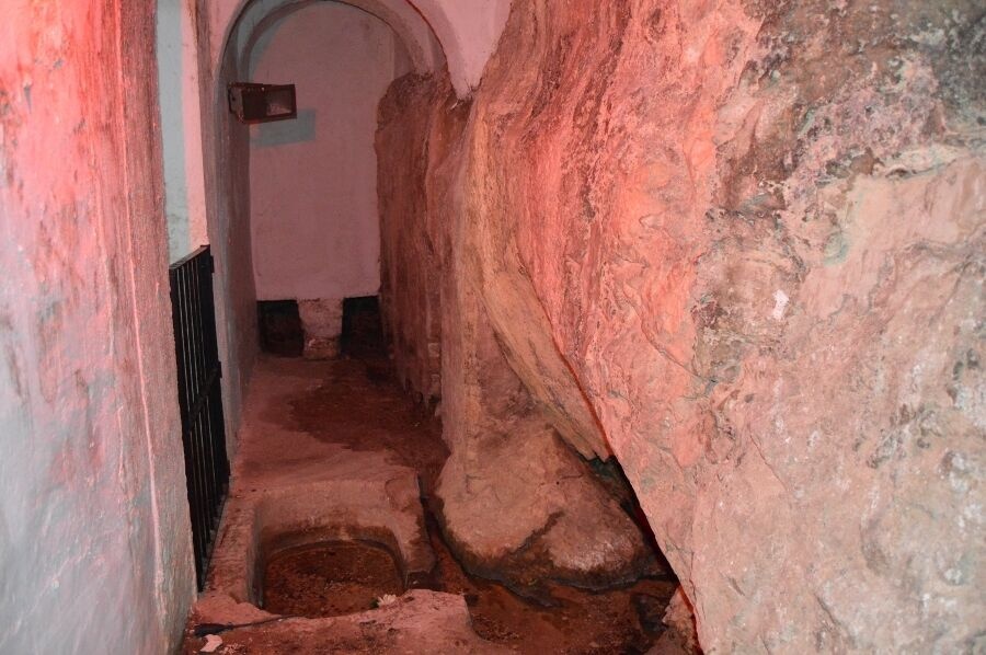
Also called Ojo de Roya (eye of Roya) by the locals, the origin of this spring used to be inside a private property, specifically a country house. Water has always been a very scarce and therefore valuable resource in this region. For this reason, during the rule of the Order of Santiago over Estepa, people already paid for the water that came out of this spring.
The water from the spring flows towards a fountain located on the side of the hill and it serves as a place for it to converge. This water is then conducted to the cisterns, where it flows into a pipe. One of the stones from the fountain has two inscriptions, one that reads “1733” and the other “1842”. The latter is thought to be the year in which the fountain was built and the water from the spring was brought to the city.


These hills are located between Estepa and Pedrera, a nearby town, and have two peaks, one at 783 metres above sea level and a slightly lower one at 724.
The Sierra de Pleités is essentially a low-production large olive grove used for pasture. It is located between the Sierra de la Cruz hills, the Cerro del Chichón hills and La Roda de Andalucía, a nearby town. These hills are also home to the Cortijo de La Algaidilla country house, which belonged to the Sánchez Pleités family, also known as the marquises of the Soidos and Frómista.